Wednesday, May 27, 2020

Dixie National Forest (3)


[1. Red Canyon] [2. Bristlecone Pine Trail] [3. Pink Ledges/Birdeye/Hoodoo/Photo Trails] [4. Castle Bridge Trail] [5. Golden Wall Trail]


IMG_5025 Red Canyon, Dixie National Forest
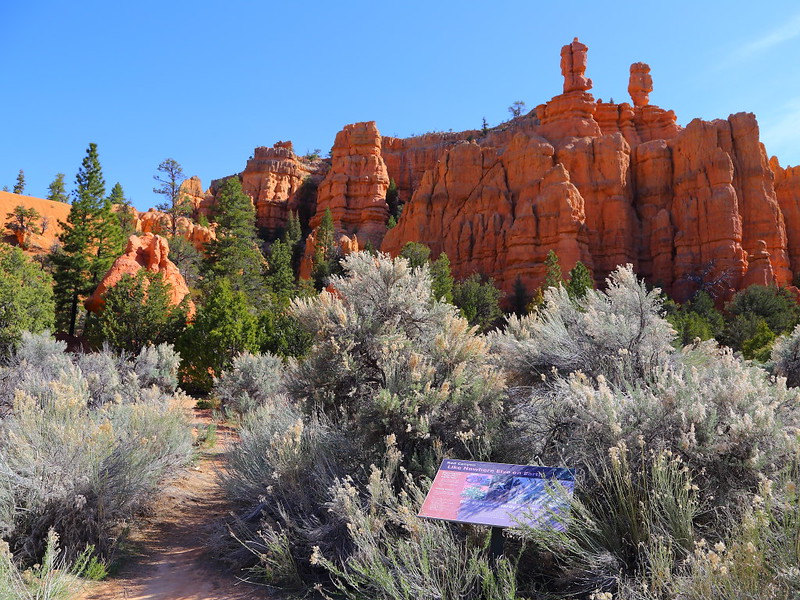
Figure 3.1: Red Canyon位於UT-12上的步道口。

IMG_5028 Hikers on Hoodoo TrailRed Canyon
Figure 3.2: Hoodoo Trail很短很平,不過大部分的hoodoos都被樹擋住。

IMG_5053 Birdeye Trail, Dixie National Forest
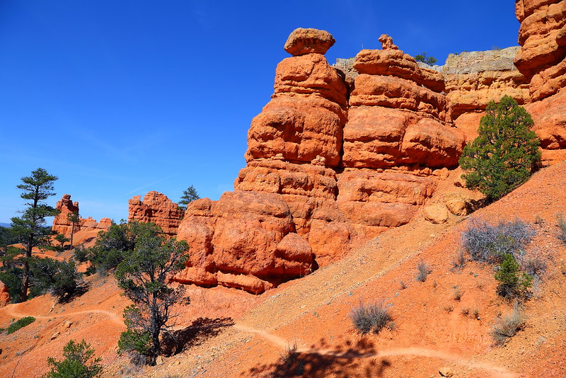
Figure 3.3: Birdeye Trail會走到稍微高的地方。

IMG_5057 Red Canyon
Figure 3.4: Birdeye Trail上的hoodoos。

IMG_5063 Red Canyon, Dixie National Forest
Figure 3.5: Birdeye Trail的另一個地方。

IMG_5064 Red Canyon
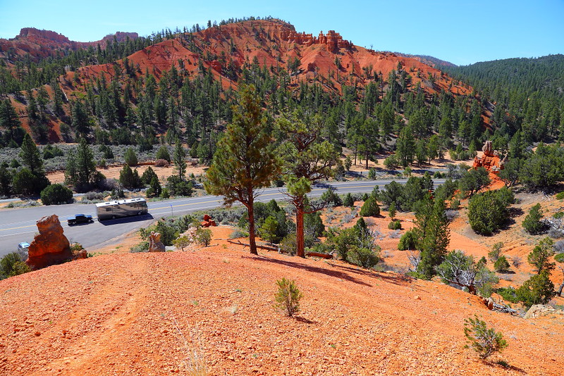
Figure 3.6: 從Photo Trail俯視UT-12。

3. Pink Ledges/Birdeye/Hoodoo/Photo Trails

Red Canyon除了在馬路旁有些地方可以停車拍照,也有不少步道可以走。大部分人的主要目標是Bryce Canyon,會花時間在這走步道的人很少。如果你想稍微走一下但又不想花太多時間,遊客中心附近有不少短步道可以選擇。

UT-12旁的步道包括Pink Ledges Trail、Birdeye Trail、Photo Trail與Hoodoo Trail,這幾條步道的長度都不到1 mile,有的可能只要花十分鐘就可以走完,而有的來回大概需要半小時,可以視自己的時間決定要怎麼走。除了可以用同一步道走回原處,也可以利用馬路對面的腳踏車道往回走讓視覺更有多樣性。

我自己覺得Pink Ledges Trail與Birdeye Trail的風景較好看,不過Birdeye Trail的步道稍窄,雖然還不至於有要搏命演出的程度,但走的時候還是得花精神注意,而Photo Trail也有這問題。此外,走Birdeye Trail的鞋子不要穿太差,遇到下坡的坡段會比較安全。我自己覺得Pink Ledges Trail這方面比較好,而Hoodoo Trail因為很平而沒這問題。

IMG_5071 Red Canyon, Dixie National Forest
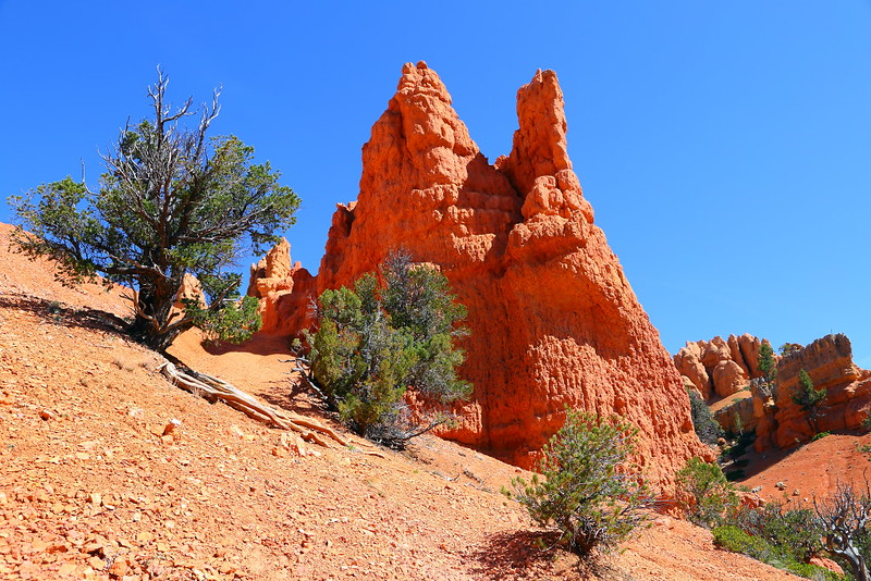
Figure 3.7: Photo Trail上的hoodoos。

IMG_5108 Red Canyon, Dixie National Forest
Figure 3.8: 這是從馬路對面腳踏車道看的景色。

IMG_5112 Red Canyon
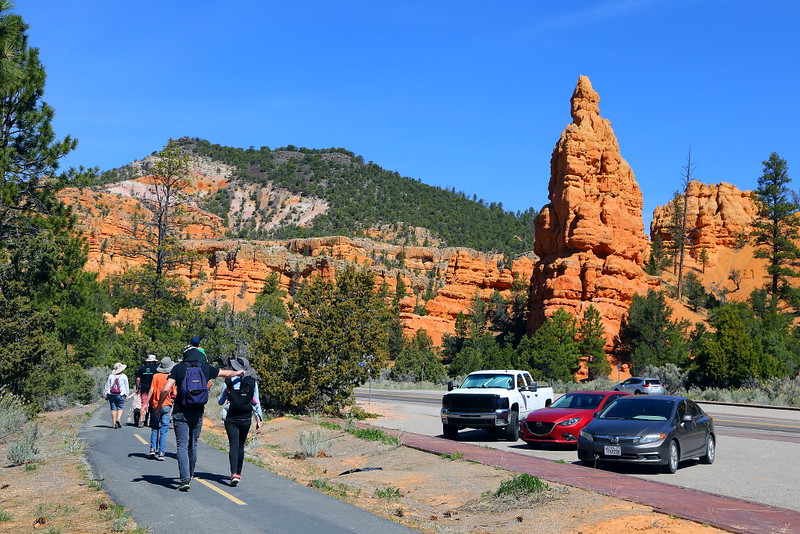
Figure 3.9: 雖然是腳踏車道,也可以用走的,冬天應該也可以cross country skiing。

IMG_5140 Hoodoos at Red Canyon
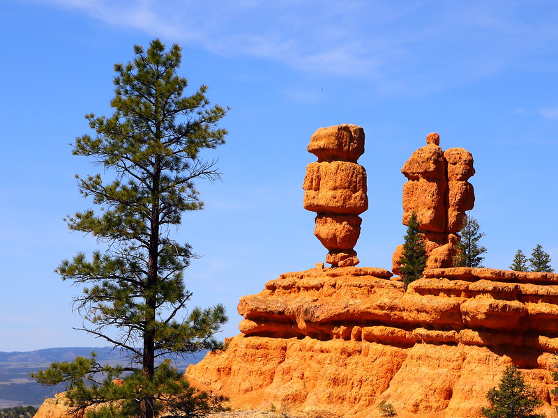
Figure 3.10: 從Pink Ledges Trail上看到的小不點hoodoos。

IMG_5151 Red Canyon, Dixie National Forest
Figure 3.11: 從Pink Ledges Trail這地方看到的這個角度不錯。

IMG_5154 Hoodoos at Red Canyon
Figure 3.12: 上圖中間hoodoos的特寫。

走這些步道的人不會太多,理應不會像Bryce Canyon裡的熱門步道Navajo Loop Trail人多吵雜,不幸的是這並不是事實。這些步道都離馬路不遠,加上不少人都開快車去Bryce Canyon或從那方向過來,常常聽到這些車輛的呼嘯聲音,所以還蠻吵的,是走這些步道的缺點。

我花了一個半小時左右走完這些步道,風景看起來是沒有比Bryce Canyon那幾條主要步道精彩,但還是有相當的可看性,加上距離短且坡度緩,走起來較輕鬆。不過如果你喜歡騎腳踏車,Red Canyon會勝過Bryce Canyon,因為騎在Red Canyon的腳踏車道可以看到hoodoos,但Bryce Canyon看到的都是樹林與meadow。

Previous Next


[1. Red Canyon] [2. Bristlecone Pine Trail] [3. Pink Ledges/Birdeye/Hoodoo/Photo Trails] [4. Castle Bridge Trail] [5. Golden Wall Trail]

Tuesday, May 19, 2020

Eastern Sierra (3-2)


[1. Introduction] [2. Sightseeing] [3. Hiking] [4. Winter Activity]


3. Hiking

[3-1. Cottonwood Lakes/Muir Lake] [3-2. New Army Pass] [3-3. South Fork Lakes/Cirque Lake] [3-4. Chicken Spring Lake/Cottonwood Pass] [3-5. Kearsarge Pass/Kearsarge Lakes] [3-6. Big Pine Lakes] [3-7. Little Lakes Valley/Morgan Pass] [3-8. Lamarck Lakes] [3-9. Bishop Pass] [3-10. Treasure Lakes] [3-11. Chocolate Lakes Loop] [3-12. Sabrina Basin/Hungry Packer Lake]

3-2. New Army Pass

IMG_2793 New Army Pass Trail, Inyo National Forest
Figure 3-2.1: New Army Pass的步道口跟Cottonwood Lakes相同,一開始走的路也相同,之後才分道揚鑣。

IMG_2809 Backpackers on New Army Pass Trail
Figure 3-2.2: 這是熱門的backpacking步道,不管之後是要往New Army Pass或Cottonwood Lakes的方向去。

IMG_2875 Hikers in John Muir Wilderness
Figure 3-2.3: 不認識的山友們常喜歡在路上聊天。

IMG_2899 Foxtail Pine at Cottonwood Lakes Basin
Figure 3-2.4: 進入Cottonwood Lakes Basin,這樹是foxtail pine,樹的上半部已經幾乎死掉,下半部看起來算健康,半死半活的樣子很像Great Basin bristlecone pine

IMG_2912 Cottonwood Lakes Basin, Inyo National Forest
Figure 3-2.5: 這應該是Cottonwood Lake 1。

IMG_2952 Cottonwood Lake 2
Figure 3-2.6: 離開Cottonwood Lake 1不久就會看到Cottonwood Lake 2。

Cottonwood Lakes的步道口也可以走到其他地方,而New Army Pass是另一個很有挑戰性的day hiking地點。從步道口來回New Army Pass的來回距離是15 miles,爬升約2,400 feet到最高點12,315 feet,高海拔加上路遙且陡,當天來回需要很好的體力,用backpacking分天進行可能會是較好的做法。

用Eastern Sierra的標準,這難度算很標準而不是最難的,但對大部分的觀光客來說是自己找罪受。體力沒那麼好的話可以Long Lake、High Lake或是叉路上的South Fork Lakes與Cirque Lake當終點,難度比走到New Army Pass容易不少,但依然需要夠好的體力。總之,走這步道的仍然是以山友或是當地居民為主,經驗上backpacker的比例比day hiker要來得高。

跟走去Cottonwood Lakes相同,得先走完4 miles左右的上坡路,之後會從另一側進入Cottonwood Lakes Basin並看到Cottonwood Lake 1與Cottonwood Lake 2,是辛苦一陣子後可以欣賞風景並稍作休息的路段。繼續走會緩緩上坡到達Long Lake與High Lake,這兩個湖看起來都不錯,不想繼續走的話是可以就此當終點。如果你的目標是當天來回New Army Pass,可能沒有太多的心情在這逗留,之後還有一段艱辛的上坡得克服。

IMG_2966 New Army Pass Trail
Figure 3-2.7: 這些樹不是lodgepole pine就是foxtail pine。

IMG_2978 Long Lake, Inyo National Forest
Figure 3-2.8: 經過Long Lake這很菜市場名稱的湖。

IMG_2998 High Lake, Inyo National Forest
Figure 3-2.9: 繼續往上走會經過High Lake,這湖走孤寂風格。

IMG_3028 Lakes from New Army Pass Trail
Figure 3-2.10: 爬到夠高後可以看到之前的湖,最前面的兩個是High Lake與Long Lake,之後那三個應該是South Fork Lakes。

IMG_3049 New Army Pass Trail, John Muir Wilderness
Figure 3-2.11: 走到這的海拔差不多有12,000 feet,離New Army Pass已經不遠。

IMG_3069 New Army Pass, Sequoia National Park
Figure 3-2.12: 終於到達New Army Pass,也是Inyo National Forest與Sequoia National Park的交界。

這段High Lake後的上坡路得爬到12,315 feet的最高點New Army Pass,住在平地的人大都會感受到高海拔空氣稀薄的影響,比如腿很重、走起來很喘、頭痛或是當天晚上睡不著覺等等。好消息是在爬得夠高後可以看到如Figure 3-2.10的俯視風景,反正覺得累就稍作休息並欣賞腳下的風景,持續前進總是走得到最高點New Army Pass。

既然這地方叫做New Army Pass,表示之前已經有個地方叫做Army Pass,就在稍微北邊約0.5 mile的地方。不幸的是Army Pass那地方的積雪融得慢,讓人很難pass,因此之後改道至現今的New Army Pass。這步道是當年美國陸軍管理Sequoia National Park時蓋出來的,所以名子相當陽剛,跟Generals Highway、General Sherman、General Grant完全是同一個調調。如果你查一下地圖,會發現這隘口附近還有Soldier Lakes與Major General這種地名。

Sierra Crest有幾個可以(相對)容易穿越兩側的隘口,New Army Pass是其中之一,也是Inyo National Forest與Sequoia National Park的交界。對大部分的day hiker來說,很難繼續往Sequoia National Park走多遠,需要靠backpacking才能夠在這國家公園的backcountry深入探索。

New Army Pass這地方處在tree line上的alpine zone,別說樹長不出來,連草都很難在這生長。視覺感受相當孤寂且毫無生意,所謂的lonely planet大概就是如此吧!這地方也可以看到48州的最高峰Mount Whitney,不過這角度看起來沒有比從US-395上Lone Pine這小鎮好看就是。也許早個兩、三星期走到這地上還會有一些積雪而較好看,但爬高時路上可能會有積雪而增加危險性(帶個traction device之類的會有幫助),要兼顧風景與安全並不總是那麼容易。

IMG_3123 Hikers at New Army Pass
Figure 3-2.13: 這地方屬於Sequoia National Park,因為已經在樹線之上,一整個毫無生意的月球表面類型景觀,右邊那個被光打亮緩緩上升的山頂就是48州最高峰Mount Whitney。

IMG_3103 Hikers Ascending New Army Pass
Figure 3-2.14: 有千山我獨行的fu。

IMG_3189 Hikers at New Army Pass
Figure 3-2.15: 這群人在這休息並準備下山。

IMG_3200 Hikers Descending New Army Pass
Figure 3-2.16: 高處算是樹長不出來的alpine zone,繼續往下走就會變成樹剛可以長出來的subalpine zone。

IMG_3239 Long Lake, Inyo National Forest
Figure 3-2.17: 回到比較有綠意的Long Lake。

IMG_3297 New Army Pass Trail
Figure 3-2.18: 回到步道口。

Sequoia與Kings Canyon這兩個國家公園的backcountry被刻意保護,也就是不蓋像Yosemite的Tioga Road讓大家可以用開車的方式輕鬆欣賞風景,因此可玩性對大部分的人來說較低。但如果你身強體壯外加美國時間多,可以從Eastern Sierra進入公園而看到大部分人沒看到的景緻,對這兩個國家公園的評價也會高很多。

如果你對Kings Canyon的backcountry有興趣,可以嘗試Kearsarge Pass與Bishop Pass這兩個也是Eastern Sierra的熱門步道。這幾個進入Sequoia與Kings Canyon的隘口海拔都在12,000 feet左右,大約需要在七月中之後積雪才能融到夠少適合行走,要走之前最好先查一下步道狀況

視覺上來說,New Army Pass比Cottonwood Lakes豐富很多,不過對體力的需求也比較高,尤其是要當天來回的話。我覺得兩個地方都值得走,看自己當時的體力、心情、步道狀況與天氣。不想太操的話,Cottonwood Lakes是比較好的選擇,可以在湖邊就地搞些比如調素琴閱金經(要念心經當然也可以)的輕鬆活動,玩夠了再走回步道口。

Previous Next


[3-1. Cottonwood Lakes/Muir Lake] [3-2. New Army Pass] [3-3. South Fork Lakes/Cirque Lake] [3-4. Chicken Spring Lake/Cottonwood Pass] [3-5. Kearsarge Pass/Kearsarge Lakes] [3-6. Big Pine Lakes] [3-7. Little Lakes Valley/Morgan Pass] [3-8. Lamarck Lakes] [3-9. Bishop Pass] [3-10. Treasure Lakes] [3-11. Chocolate Lakes Loop] [3-12. Sabrina Basin/Hungry Packer Lake]

[1. Introduction] [2. Sightseeing] [3. Hiking] [4. Winter Activity]

Tuesday, May 12, 2020

Eastern Sierra (3)


[1. Introduction] [2. Sightseeing] [3. Hiking] [4. Winter Activity]


3. Hiking

[3-1. Cottonwood Lakes/Muir Lake] [3-2. New Army Pass] [3-3. South Fork Lakes/Cirque Lake] [3-4. Chicken Spring Lake/Cottonwood Pass] [3-5. Kearsarge Pass/Kearsarge Lakes] [3-6. Big Pine Lakes] [3-7. Little Lakes Valley/Morgan Pass] [3-8. Lamarck Lakes] [3-9. Bishop Pass] [3-10. Treasure Lakes] [3-11. Chocolate Lakes Loop] [3-12. Sabrina Basin/Hungry Packer Lake]

3-1. Cottonwood Lakes/Muir Lake

IMG_5673 Cottonwood Lakes Map
Figure 3-1.1: 步道口的地圖,注意地圖上第三個Cottonwood Lake旁的那個小湖沒有被標號,但有的步道指南有標。

IMG_5438 Cottonwood Lakes Trail
Figure 3-1.2: 不用走多久就會進入Golden Trout Wilderness,之後會進入John Muir Wilderness。

IMG_5442 Cottonwood Lakes Trail
Figure 3-1.3: 步道前段大概都是這個調調,大都是樹林,有時會有meadow。

IMG_5460 Cottonwood Lakes Basin
Figure 3-1.4: 走到這剛要進入Cottonwood Lakes Basin。

IMG_5473 Cottonwood Lakes Basin, Inyo National Forest
Figure 3-1.5: 進入Cottonwood Lakes Basin後視野馬上變得寬廣,前方是其中一個Cottonwood Lake。

IMG_5477 Cottonwood Lakes Basin
Figure 3-1.6: 這個湖看起來很淺,就是步道口地圖上第三個Cottonwood Lake旁那個沒有被標號小湖。

IMG_5488 Cottonwood Lakes Basin
Figure 3-1.7: 整路上的樹大都是lodgepole pine或foxtail pine。

Eastern Sierra的高山除了可以從US-395這馬路上欣賞,也提供不少hiking與backpacking的機會,而Cottonwood Lakes是其中的熱門地點之一。從US-395到達Lone Pine這小鎮後先轉向Whitney Portal Road這路,不久左轉Horseshoe Meadow Road並一路開到底就可以到達Cottonwood Lakes的步道口。這段從Lone Pine到步道口的路需要開大概四十五分鐘,請耐心慢慢開。

步道口的地圖標示了五個Cottonwood Lakes,大部分的人會以Cottonwood Lake 4或旁邊的Cottonwood Lake 5當作終點,順著Cottonwood Lakes Trail來回最遠Cottonwood Lake 4的來回距離大約是12 miles,爬升大概1,500 feet這還不算太困難的坡度。這樣走並不會經過前兩個湖,體力沒問題的話是可以稍微繞一下去看這兩個湖就是,雖然我對那兩個湖沒甚麼太大的印象。

用Eastern Sierra的標準,走到最後一個湖的難度不算難,不過因為從頭到尾都在10,000 feet以上,這1,500 feet的坡度加上不算短的距離還是有可能讓人感受到高山症的存在而覺得不舒服。雖然來回12 miles的距離是可以用day hiking的方式完成,就我個人的經驗,比較多人是以backpacking的方式進行,走起來也比較不趕。

IMG_0092 Foxtail Pine
Figure 3-1.8: 這是foxtail pine的樹葉與松果。

IMG_5495 Hiker at Cottonwood Lake, Inyo National Forest
Figure 3-1.9: 這是地圖上的Cottonwood Lake 3。

IMG_5502 Cottonwood Lake, Inyo National Forest
Figure 3-1.10: 另一個角度看上圖的Cottonwood Lake 3。

IMG_5519 Cottonwood Lake
Figure 3-1.11: 這是最後兩個Cottonwood Lake中的Cottonwood Lake 5。

IMG_5524 Hiker toward Cottonwood Lake, Inyo National Forest
Figure 3-1.12: 正要從Cottonwood Lake 5走向Cottonwood Lake 4。

IMG_5639 Hikers at Cottonwood Lake
Figure 3-1.13: Cottonwood Lake 4的湖岸,看起來是個位於冰河源頭的cirque lake。

這步道有很長的路段走在樹林與meadow之間,大概要走4 miles且爬完大部分的坡度後才會到達風景較有看頭的Cottonwood Lakes Basin,之後走起來就輕鬆且賞心悅目很多。話雖如此,這對大部分的觀光客來說投資報酬率低了點,主要是加州居民或是對登山有熱情的人在走。

在這幾個Cottonwood Lake裡,最遠的Cottonwood Lake 4也許是最好看的,也是大部分人的終點。雖然走到這需要花一番力氣,我發現不少人是專門到這釣魚的,而釣的是加州州魚golden trout。這魚算是保育史的success story,因為曾經瀕臨絕種,在相關人士努力之下救回並存活在今日的不少地方。看是在什麼地方釣這魚,有些地方釣到可以帶走,但有的地方必須catch and release。

進入Cottonwood Lakes Basin後有個可以往Muir Lake的支線,來回這湖的距離大概1 mile,湖岸有較多的樹使得視覺上較有生意,最後兩個Cottonwood Lake看起來就比較孤寂,喜歡哪種調調就看人了。因為我第一次沒走去Muir Lake,所以第二次先去看這湖,結果不久之後開始烏雲密布還順便打雷,所以放棄繼續走到Cotttonwood Lake 4的計畫而馬上下山以策安全。

IMG_5593 Fishing at Cottonwood Lake
Figure 3-1.14: 不少人專程走到這釣魚,尤其是最後這兩個湖。

IMG_0028 Golden Trout, Inyo National Forest
Figure 3-1.15: 還記得之前提到的Golden Trout Wilderness嗎?這就是golden trout。

IMG_5557 Cottonwood Lake
Figure 3-1.16: 可以繼續走到Cottonwood Lake 4的另一端,這是我走到最遠的地方,可以從這湖的另一端回望。

IMG_5618 Camping at Cottonwood Lake
Figure 3-1.17: 有人在Cottonwood Lakes的湖旁紮營過夜。

IMG_0053 Yellow-Bellied Marmot, Inyo National Forest
Figure 3-1.18: 回程時看到的yellow-bellied marmot。

IMG_3690 Muir Lake, Inyo National Forest
Figure 3-1.19: 這是另一次去的Muir Lake。

IMG_3736 Muir Lake, Inyo National Forest
Figure 3-1.20: 有人在Muir Lake裡游泳。

Cottonwood Lakes算是典型Eastern Sierra的高山湖風景,也常常是有志探索Eastern Sierra高山者的前幾個目的地。我自己第一次來這是為了找Sierra Nevada bighorn sheep,不過沒有如願。我自己還蠻喜歡Cottonwood Lakes Basin這一區的環境,加上附近還有其他的地方可以走去瞧瞧,前前後後走到這已有五次之多。

不算是嚇死人的風景,但利用周末來回就可以欣賞到這種等級的山水,沒有擁擠與叫囂的人潮,還可以順便練身體與增強心肺功能,我想是沒什麼好抱怨的。

Previous Next


[3-1. Cottonwood Lakes/Muir Lake] [3-2. New Army Pass] [3-3. South Fork Lakes/Cirque Lake] [3-4. Chicken Spring Lake/Cottonwood Pass] [3-5. Kearsarge Pass/Kearsarge Lakes] [3-6. Big Pine Lakes] [3-7. Little Lakes Valley/Morgan Pass] [3-8. Lamarck Lakes] [3-9. Bishop Pass] [3-10. Treasure Lakes] [3-11. Chocolate Lakes Loop] [3-12. Sabrina Basin/Hungry Packer Lake]

[1. Introduction] [2. Sightseeing] [3. Hiking] [4. Winter Activity]